Human Scale Design in Central Honolulu Part 2
Reclaiming the King-Beretania Corridor for People in the McCully-Mo’ili’ili Neighborhood
By Alex Broner
For Part 1 click here.
What can be done?This report is intended to define the problem, highlighting some specific aspects of non-human scale design in McCully Mo’ili’ili, and identify some potential solutions. The actual implementation of solutions is a more involved process requiring communication and negotiation with multiple stakeholders. Nevertheless, if we don’t have any idea of what the end product is it’s hard to convince people to get involved at all and harder still to figure out what to do.
1. The role of streets
Social activity
Janh Gehl describes street activities as fitting into three categories:
necessary activities, optional activities, and “resultant” or “social” activities. When the physical environment is poor, only necessary activities are conducted and people hurry on to other things. When the physical environment is good, people tend to conduct as many necessary activities though they tend to take longer. They also conduct far more optional activities such as sitting and talking, eating, or generally hanging out. It is under these conditions that social activities result. This can be acquaintances running into each other, children starting games, or merely strangers exchanging smiles. (Gehl 11-17)
Safety
One of the key roles that well designed streets fill is maintaining the safety of their inhabitants. Jane Jacobs says “...sidewalks and those who use them are not passive beneficiaries of safety or helpless victims of danger. Sidewalks, their border uses, and their users, are active participants in the drama of civilization versus barbarism in cities.” (Jacobs p 30) The way that sidewalks maintain safety is through the attention of people in and around them. People walking down a sidewalk naturally observe each others activities. People in surrounding buildings also watch the street if their view is unobstructed and it is interesting to do so. It is only when a sidewalk is allowed to become isolated and cut off from this passive and casual surveillance that the danger of crime becomes quite real. (Jacobs 34-36)
What makes for a good street?
A good street is a well traveled street and a well traveled street is a street with many sources and destinations for people. Jacobs focuses upon ensuring streets have a “multiplicity of uses” which generate pedestrians at different times of the day. Continuous use is necessary to ensure that a street is both interesting and safe, and thus is capable of generating additional interest as a place to go be around people. Gehl focuses on the spatial aspect of this, reflecting on what he calls “segregation vs assembly” of functions. Segregation is a result of spreading out activities and otherwise erecting impermeable barriers between them. On the other hand, he says of assembly: “If activities and events are to be assembled, it is possible for individual events...to stimulate one another. Participants in a situation have the opportunity to experience and participate in other events. A self reinforcing process can begin.” (Gehl 83) Furthermore, he adds “It is of prime importance to recognize that it is not buildings, but people and events, that need to be assembled.”
Case study: King/Beretania
We will examine how well King and Beretania streets serve as pedestrian streets. It is not enough to point out that the pedestrian environment is poor, which it is. It is not enough to point out that those who do walk down the street tend to hurry by and not linger, which they do. Rather we will look at specific aspects of this problem and potential solutions. We will look at the form and function of the streets as well as the buildings and even the parks that abut it.
Element one: the street itself
As we saw with our initial comparison of Broadway in Seattle to King Street, the function of the street is very important to an areas character. All else equal, the greater volume and speed of automobile traffic the lower the number of pedestrian uses that will go on nearby. Thus we see elsewhere in Honolulu in the Chinatown district large numbers of pedestrians during the day.
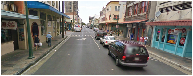
Photo credit: Google.
Here’s a picture of Maunakea Street in the Chinatown district. Notice that the street is about 44 feet wide while King Street and much of Beretania street are 66 feet wide: 22 feet wider than Maunakea Street in Honolulu and 12 feet wider than Broadway on Capitol Hill. How much of a difference does the extra 11 feet make? Notice in this picture how much detail one can pick up on either side of the street. Based on my own personal observations I postulated that when streets are overly large they tend to deaden the sense by imposing too much space between the pedestrian and people and objects on the opposite side.
Janh Gelh provides useful information that helps us quantify the tradeoffs of wider vs. narrower streets. Here is a table showing the human visual capability in terms of its ability to pick up socially important detail. The level of detail people can pick up at a given distance is listed on the left and the minimum and maximum distance at which they can pick it up is on the right.
visual capability
|
min distance (ft)
|
max distance (ft)
|
See others and see that they are people
|
1600
|
3200
|
See that they are individuals
|
325
|
325
|
Detect general characteristics (sex, approximate age, what people are doing)
|
250
|
325
|
Hair style, age, people met infrequently identified
|
100
|
100
|
Detect feelings and moods. "At this point the meeting begin(sic) to become truly interesting and relevant in a social context."
|
60
|
80
|
normal conversation takes place
|
3
|
10
|
(Gehl pg 67)
We are particularly interested in the highlighted portion, the distance at which feeling and moods can be detected. It is within this distance that the transition from isolated to social individuals takes place. It is at this distance that people decide whether or not they’d like to move to more intimate contact, whether it’s an acknowledging nod, a few words, or more involved conversation. People who do not pass within 60-80 feet of each other do not then have the option of proceeding to the 3 to 10 feet distance.
On any given street no matter how wide or narrow it is, one can see people on the same side of the street (at the same distance) in the same degree of detail. The difference between a narrow street and a wide street is the amount of detail one can see on the opposite side or put another way, the amount of social space one can view. For our purposes we’ll go with the maximum distance of 80 feet. This is because we wish to establish a conservative estimate of how wide a street is too wide to allow pedestrians to engage with each other and objects on the other side of the street.
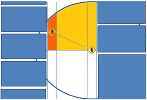
In the bellow diagram the red shaded area is the “social space” of the sidewalk on the opposite side of the street. Within this space a person on the opposite side (in yellow) can reasonably be expected to visualize a certain level of details on facial expressions.
The below tables show the social space area calculated for different street widths. I’ve assumed a 10 foot sidewalk and that both the viewer and viewed are walking down the middle of the sidewalk on opposite sides of the street. The only variation is the street width, given here as the “curb to curb” distance.
street width (curb to curb in feet)
|
sidewalk width (feet)
|
social range (feet)
|
socially visible space on opposite sidewalk (feet)
|
percent increase of space from road narrowing
|
viewing time at walking speed (seconds)
|
60
|
10
|
80
|
374
|
3.2
| |
50
|
10
|
80
|
524
|
40.3
|
5.3
|
40
|
10
|
80
|
621
|
18.6
|
6.6
|
30
|
10
|
80
|
691
|
11.1
|
7.5
|
20
|
10
|
80
|
740
|
7.1
|
8.2
|
10
|
10
|
80
|
773
|
4.5
|
8.6
|
Note that as one takes space away from a 60 foot street to a 50 foot street the amount of social space goes up by 40.3%. From 50 to 40 feet the improvement is a more modest 18.6% and one sees declining returns from there. Also note that two people walking down a 60 foot street at 3.3 miles an hour have only 3.2 seconds of visual contact while on a 50 foot street they have 5.3 seconds of contact.
Going from a 60 foot street to a 50 foot street does have consequences for vehicular traffic, and these must be weighed against the gains in pedestrian traffic resulting from a more socially enjoyable environment. Each lane of lost space constitutes a percent decrease in capacity. I’ve constructed the below chart to show the gains in social space and how they compare to losses in lane space.
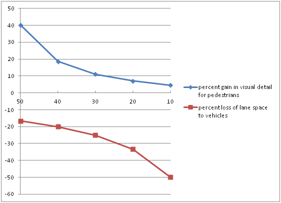
Going from 60 to 50 feet constitutes a 16.6% loss of lane space but increases the social space by 40%. Going from 50 to 40 feet has about equivalent losses to automobiles and gains to pedestrians.
All of which is to say there is a very strong case for a “50 foot rule” for street width in urban areas. King and Beretania Streets are good candidates for this kind of treatment.
Making King and Beretania into Complete Streets.
While reducing the width of the street is an important project, it is also important to change the function of the street to emphasize all modes of travel, not just private automobiles. Towards this end space needs to be re-allocated from cars to pedestrians, cyclists, and transit riders. I will attempt here to outline some of the challenges and possibilities in this corridor, there is more than enough that needs to be said and done on the subject to fill an entire report.
First let us deal with the generic configuration of King and Beretania when they act as a couplet. The intersection with University Ave has its own challenges and opportunities but we will set that aside for now and return to it later.
The Honolulu Bicycle Master plan envisions King, Beretania, and Young street as part of the Honolulu bicycle network. Indeed, King/Beretania are identified as “priority 1” projects in the plan. (Honolulu Bicycle Master Plan, pg 13) Nevertheless, any transfer of lanes from general purpose lanes to bicycles is bound to be controversial. In 2001 for example when the Harris administration attempted to implement is BRT proposal it was met with local opposition from residents. (Meeting of McCully Mo’ili’ili Neighborhood board,
As far as bus lanes, my own study of bus rapid transit in this corridor “A King-Beretania BRT proposal” concluded that bus lanes were not applicable within the MM neighborhood. The TCRP report 118 (4-17) states “The bus lanes should carry as many people as in the adjacent general traffic lane. Generally, at least 25 buses should use the lanes during the peak hour.” As I concluded in this paper that the 10 buses that travel through MM along King-Beretania in each direction in the peak period don’t constitute sufficient demand to justify taking away general purpose lanes as bus lanes.
How then to reclaim the street if bus lanes are impractical and bike lanes controversial? Remember if you will our example of Broadway in Seattle. While the curb to curb distance is sufficient for 5 through lanes, only two such lanes are striped. An additional 2 lanes are devoted to round the clock parking and a center turn lane serves also as an island for pedestrians and for trucks delivering to local businesses. It is local businesses who have the potential In the winter and spring of 2010 I was involved with the Capitol Hill Community Council Complete Streetcar Campaign. We successfully convince the city to implement a streetscape design that reduces the space for automobiles down from 3 lanes to two and adds a dedicated cycle track. A major part of our success had to do with winning over the support of the business community in the form of endorsements of our proposal from the Capitol Hill Chamber of Commerce. One reason we gained support from the chamber is because our plan involved maintaining the most on-street parking of the alternatives being considered.
On-street parking is generally a pedestrian friendly use of the street. People most of the time need to park some distance from their destination and thus on-street parking generates more pedestrians than on-site parking. Onstreet parking also acts as a physical buffer between moving traffic and the sidewalk and provides “surface friction” that helps calm traffic. A series of workshops on traffic calming in MM school areas were conducted by the Honolulu department of transportation services in 2001. The workshop documents identify various intersections and mid-block crossings where curb extensions aka “bulbouts” could reduce the pedestrian crossing distance. (Mo’ili’ili School Areas handout 2001) The Complete Streetcar Campaign in Seattle similarly identified bulbouts as a key feature of our street typical. In my study of King-Beretania BRT Proposal I furthermore identified bulbout stations both as a way of creating space for more space intenstive bus stops and for moving the bus travel lane out from the rightmost lane which is frequently slowed by right turn movements. If we can fund the necessary concrete for curb extensions and acquire the necessary political support for bike lanes, then this corridor stands a good chance of achieving complete street status. Even if these things are done, we’ll still be left with the design problem that is the intersection of King, Beretania, and University Ave.
University Ave: A Street that is asked to do too much.
University Avenue is a 6-7 lane street that is asked to fulfill the following roles: It is a major arterial connecting the Manoa Neighborhood to the University and to McCully Mo’ili’ili and the rest of Honolulu. It also acts as the center of a major highway interchange for these areas. On top of that it is expected to handle the large amount of Pedestrian, Transit, and Bicycle traffic associated with the University. All in all, this is a street being asked to do too much. In actuality the street performs its automobile functions decently, its transit functions mediocre, and its bike/pedestrian functions poorly.
My proposed solution to this problem is to create a new connection that crosses H1 and takes on some of the traffic load. By expanding the total through lanes in each direction, lanes can be dedicated to transit and bicycles and pedestrian conflicts reduced without the necessity of reducing auto throughput dramatically. This helps avoid the political obstacle of pushback from drivers.
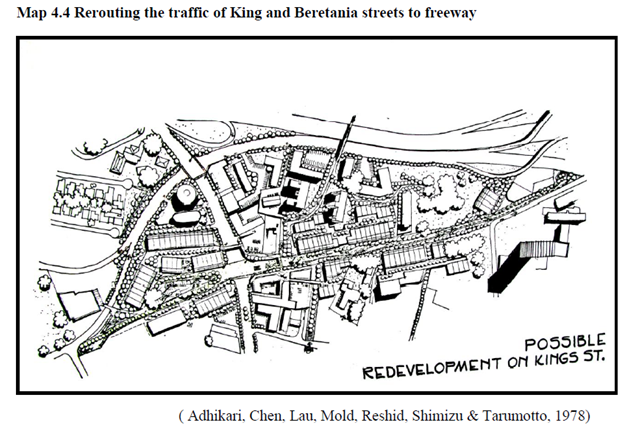
The basic idea is to extend Isenberg north of H1, constructing a new, low footprint interchange where Isenberg crosses H1. This allows us to decommission parts of the University-H1 interchange that produce conflicts with pedestrians and cyclists as well as introduce traffic backups on University Ave. At the same time, Beretania’s existence as part of a couplet with King is extended, allowing lanes on King Street to be repurposed for bicycles and transit. Here’s a diagram of the plan in its basic form:
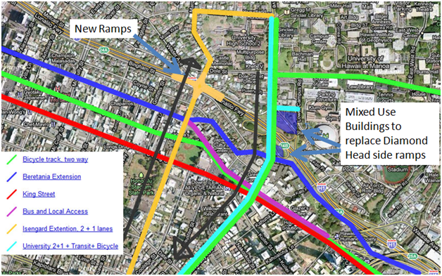
Note that the black arrows show the primary direction of the 2 lanes on University and Isenberg, with one general purpose lane on each street running in the opposite direction. To explore this map online, go here.
(It should also be noted that this plan is similar to a 1978 plan cited by the 2008 McCully-Mō-„ili„ili Neighborhood Planning Study (pg 4-20). See attachment 1 at the end for that map.)
The advantage of this plan is that it maintains similar through-lane capacity for cars and buses while creating dedicated lanes for bicycles and future expansion of the rail system. It is likely that an ambitious redesign of the neighborhood will only happen as part of the University Rail Extension. Here’s a table demonstrating the old and new lane configurations:
| Screen line | Lanes Before | Lanes After |
| King/Beretania/Young at Isenberg | 11 General purpose lanes | 10 General Purpose, 1 two way bicycle track |
| King/Beretania at University | 7 General purpose lanes | 7-8 General Purpose lanes, 1 two way bicycle track |
| University/Isenberg at Kapiolani Blvd, heading to or from UH Manoa | 6 General purpose lanes | 6 General Purpose lanes, 2 rail transit lanes, 1 dedicated bicycle track |
| University Ave North of Metcalf | 6 General Purpose Lanes | 6 General Purpose lanes |
For the purpose of simplicity, in this table lanes currently devoted for parking all or part of the time are denoted as general purpose lanes.
This plan is ambitious, but not impossibly so. It was not all that long ago that H1 was engineered through this neighborhood, creating many of the problems this plan is attempting to resolve. If the initial segment of the rail plan gets built then there will certainly be an extension to the University. When this extension is built there will have to be a significant reconstruction of University Avenue. Also, with the city and county of Honolulu trying to promote transit oriented development, one could easily imagine the residential areas north of H1 near the rail line being upzoned to allow for multi-family dwellings. Under this context one could easily imagine the city buying the properties necessary for reconfiguring the streets and selling what’s left to developers for a profit.
Buildings: retrofit or redevelopment?
Buildings that have a good relationship to the street are essential for constructing a pedestrian environment that is both interesting and safe. Buildings produce pedestrians and they also act as visual stimuli for pedestrians on their way to other destinations. If they run right up to the sidewalk, buildings can support awnings that provide useful shade for pedestrians. Given how often it is either hot or pouring rain in Honolulu, the need for continuous shade cannot be over-stated. Not only do people on the street look into buildings, but people inside look out, providing both an essential public safety component. To what extent do the buildings in MM along King-Beretania perform these roles and where they come up lacking, how can they be improved?
The buildings in MM are on average quite old. In 2008 a UH Urban and Regional Planning student project titled McCully-Mō-„ili„ili Neighborhood Planning Study found that a majority of the structures in the neighborhood were over 50 years old. Despite a smattering of newer (11-25 year old) structures along the King-Beretania corridor, this corridor has ample number of old buildings. Here I reproduce a map from Chapter 5 of the study:
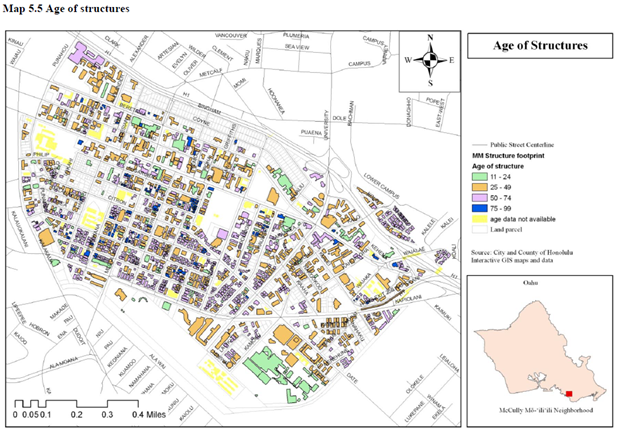
On the need for re-development, Jane Jacobs points out that having a range of buildings of different ages is desirable. Older buildings are less expensive to rent because they’ve already been paid off. At the same time, buildings tend to get run down over time and continual replacement and renovation of the building stock is necessary to prevent a neighborhood from suffering a slow death from general decay. A variety of buildings also produces a visually interesting cityscape consisting of multiple building types and styles. (Jacobs 150) In this case redevelopment offers the potential to replace or retrofit existing buildings in order to create a better pedestrian environment.
Let’s look at some specific examples:
Kokua Market
Here’s a positive example of what can be done with a building that features a large blank wall adjacent to the street. Note the provision of shade over the sidewalk and a colorful mural that provides visual stimuli to pedestrians.
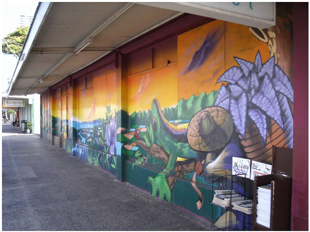
Photo credit: Google.
There are several places where this treatment may be usefully applied, including the Times Supermarket Building and the McCully Bike shop which is pictured below.
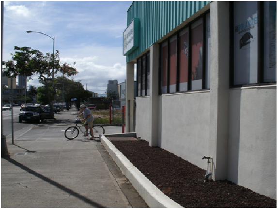
Photo credit: Alex Broner.
Note that the store owners do make a few feeble attempts at having more than just blank walls, but the end result is underwhelming from a pedestrian standpoint. Note here too that the sign is oriented so as to be more easily seen from the motorway than from the sidewalk. While “nature Band-Aids” as Kuenstler calls them are not ideal, filling the planter strip with brown gravel is hardly appealing.
Here’s a different example, the First Hawaii Building
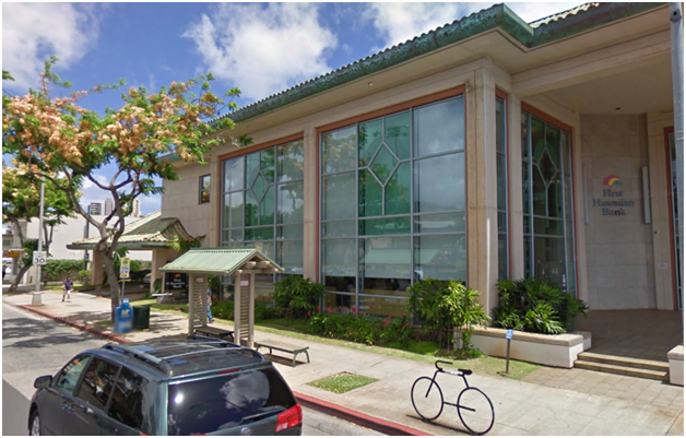
Photo credit: Google.
First, credit is due for the large ground floor window. Occupants can see the street and pedestrians can see inside, though in this photo they appear to have the blinds down. That said, this building relates to the street poorly in two ways. First of all, no attempt is made to provide shade on the sidewalk. Second of all, its current use as a bank branch means that activity inside will only occur during bank hours. At night and on weekends when other nearby businesses such as stores and restaurants are generating foot traffic, the First Hawaiian Building is lifeless. This situation can be improved via a retrofit of the front face into small store fronts of the type used by shops or restaurants. By repurposing the planting strip and bringing the building right up the curb, this retrofit can also provide shade and a more immediate pedestrian connection. The amount of space lost for bank activities would be minimal and the gain in foot traffic would benefit First Hawaiian.
“Soft Edges” The need for transition space
Here’s the front of Down to Earth market on King Street:
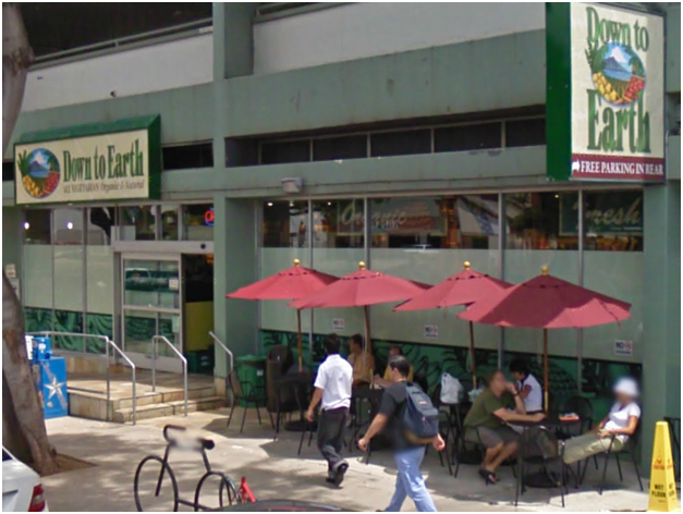
Photo credit: Google.
Jan Gehl calls them “soft edges” and uses the term to refer to the semi-public, semi-private space that fronts many buildings. He gives the example of suburban houses with a small garden plot in front and or a porch. Both the garden plot and the porch act as places for people to engage in other activities whether it be sitting and eating or doing gardening. The presence of people along the soft edge serves as an opening for interaction to occur. (Gehl 185-195) In this case we see that people (presumably customers of Down to Earth Market) use these shaded tables for eating and conversation. While it could stand some improvement, this building has a number of desirable features, including the seating, the amount of shade from street trees, plentiful bicycle parking, upstairs office uses that generate additional pedestrian traffic, and the location of vehicle parking above the store rather than as a large surface parking lot. Indeed the success of this building is evidenced by the fact that this is one of the few places in the neighborhood that features regular street performers. Street performances can be considered “resultant” or social activity; as a rule of thumb if you observe which locations are favored by street performers, sellers, and others who conduct their business on the street, you’ll find that these locations have the trappings of a quality environment for people.
The need for infill: eliminating voids.
Both Jan Gehl and Jane Jacobs warn against the deadening effect of urban voids. A human being moving at three miles an hour experiences the dullness of a parking lot, a blank wall, or an ill-used green space for quite a bit longer than a person driving at 30 miles per hour. We already talked about applying murals to blank walls and ensuring that business fronts are used intensely at all hours. Now we will look at the other two kinds of voids present along King-Beretania: parks and parking lots.
In general, parking lots should be located above or behind the street face. This doesn’t make all that much difference for the motorist but it makes a world of difference for the pedestrian. Witness for example how front parking lots move the store line farther back from the sidewalk:
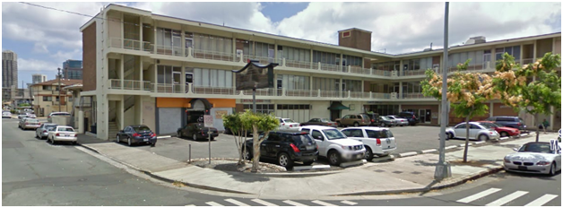
Photo credit: Google.
The already formidable distance from one side of the street to the other is compounded by needing to stare across and 40 feet to try to make out details of the various retail signs. Not being able to make out store signs compounds the problem of difficult street crossings since one is not inclined to expend energy and/or risk ones health crossing the street for a casual glance at the store front. In terms of recognizing other people, only the closest of friends or relatives is recognizable at this distance, and forget about conversation. Buildings such as these have limited potential for retrofit. In some cases the parking lot can be partially or completely filled in and the existing structure transitioned from retail to office and residential uses. It might make more sense however to tear down buildings like this and replace them. In the interim until this happens, the city should consider the possibilities of stand-alone structures to provide shade. Perhaps stand alone versions of this “sidewalk shed” design meant to protect pedestrians during construction in New York City:
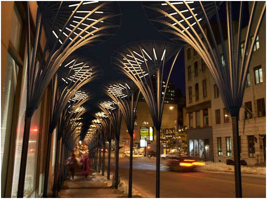
Photo Credit: Inhabitat.com
The standalone version of these “urban umbrellas” should feature signage for the businesses behind them so that they not only shade the pedestrian-way but also enhance the visual space by moving important street details right up to the sidewalk.
Active Parks
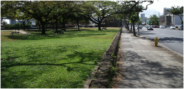
“Conventionally, neighborhood parks or parklike open spaces are considered boons conferred on the deprived populations of cities. Let us turn this thought around, and consider city parks deprived places that need the boon of life and appreciation conferred on them. This is more nearly in accord with reality…” (Jacobs 89)
It is the case that the two largest and most prominent parks in McCully Mo’ili’ili are also the most boring and most under-used. This author has walked or bicycled past these two parks day after day and found that they move between “extremes of popularity and unpopularity” (89). When a sports event is going on at one of the softball diamonds at Mo’ili’ili neighborhood parks it can be considered well used. While in addition to these events sometimes a few individuals practice baseball, the primary use of these two parks seems to be by the indigent population, who no doubt appreciate the restrooms and the fact that no one else is using the parks much of the time. Here’s a birds eye rendering of the parks which demonstrates some of the problems.
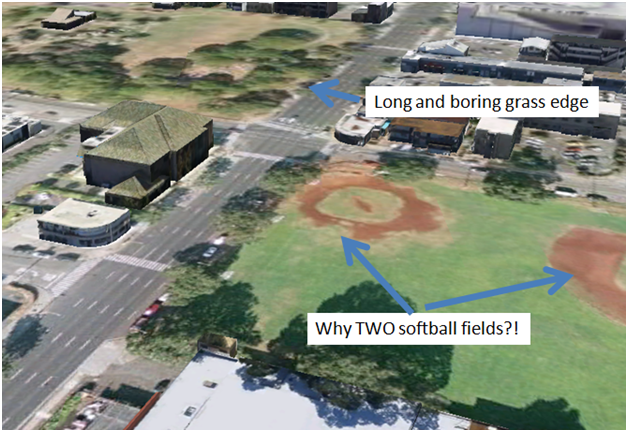
Rendered using images from Google Earth
The basic problem is that both parks contribute to what are a long series of voids. Here’s a diagram showing how severe the problem is:

All told a pedestrian on King Street has to deal with 1570 feet (or 1/3 of a mile) of utter dullness, and this is a conservative estimate! Out intrepid pedestrian cannot escape to Beretania Street because they’ll still deal with 1160 feet of soul crushing boredom by that route. How do we fix this?
Jane Jacobs and Jan Gehl would probably both agree that what is needed is a variety of active uses along the perimeter of the parks. Retail would serve this purpose quite well as it would fill in the gap in the street and also contribute pedestrians towards the remaining park space. I am mindful however that any alteration of park space is a touchy matter for people who take the current condition for granted, and removal of park space touchier still. With this in mind I developed two strategies. One is to create one story tall retail building with a green roof that transitions gradually to ground level. The amount of surface area devoted to park uses does not change and the street gets more interesting. The second strategy is to utilize more active park uses for the edges. Observation of other parks in Honolulu indicates that Basketball is quite popular and thus likely to generate continuous use. For the sake of variety I included two basketball courts and two tennis courts. Here’s a rough sketch of what the new park arrangement might look like:
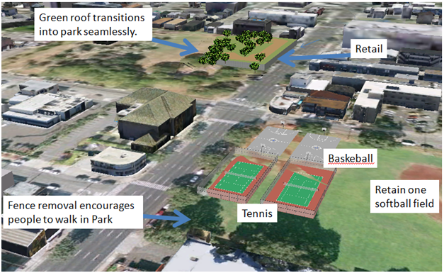
Google Sketch drawing imported into Google Earth.
Planning a major change like this cannot be done by one person; it must be a community project. Nevertheless, I maintain that by heaping love and attention on these parks in a manner similar to the one outlined above, we can make them into human scale places that residents enjoy visiting and do so often.
Conclusion
Much work is still to be done if we are to make McCully Mo’ili’ili a place that is designed with people in mind. We need to overcome decades of neglect and poor decisions. We must retrofit, rebuild, and re-imagine our streets, our buildings, and our parks. However if we come together as a community and decide to put people first, I think we can’t help but win a better neighborhood for ourselves and our children.
Attachment 1:
Works Cited:
Bicycle Master Plan, City and County of Honolulu
http://www1.honolulu.gov/dts/bikeway/
Brit Liggett, Urban Umbrellas to Replace NYC Sidewalk Sheds | Inhabitat - 01/25/10 http://inhabitat.com/urban-umbrellas-to-replace-nyc-sidewalk-sheds/
Broner, Alexander. A King-Beretania BRT Proposal, final project for Plan 648, Transportation Planning with professor Peter Flachbart, May 2011
Complete Streetcar Campaign
Website: http://capitolhillcommunitycouncil.org/campaigns/streetcar/
Facebook page:
Gehl, Jan. Life Between Building; Van Nostrand Reinhol, New York 1987
Interview with Jan Gehl 04/13/2011
http://dirt.asla.org/2011/04/13/interview-with-jan-gehl/
Jacobs, Jane. Death and Life of Great American Cities. Westminster, MD, USA: Vintage, 1992. p 105.
http://site.ebrary.com/lib/uhmanoa/Doc?id=10235265&ppg=105
Kunstler, James Howard the Tragedy of Suburbia TED Talk, Monterey California, February 2004
http://www.youtube.com/watch?v=Q1ZeXnmDZMQ
McCULLY-MO'ILI'ILI NEIGHBORHOOD BOARD NO. 8, MINUTES OF REGULAR MEETING THURSDAY, MAY 3, 2001
http://www1.honolulu.gov/refs/nco/nb8/01/8maymin.htm
McCully-Mo’ili’ili Neighborhood Planning Study, UH Manoa Department of Urban and Regional Planning, 2008
Mo’ili’ili School Areas – Potential Traffic Calming Solutions, Workshop Handout, May 16, 2001
posted by Unknown at
6:28 PM
![]()

0 Comments:
Post a Comment
Subscribe to Post Comments [Atom]
<< Home